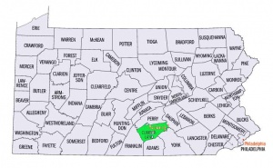
Cumberland County (Pennsylvania, USA)
Cumberland County, Pennsylvania, located southwest of Harrisburg, was carved out of Lancaster County on 27 January 1750. In 1755 the Proprietary Government suggested that the Irish settle here, leaving Lancaster for the Mennonites. Consequently the Mennonites did not move in before the late 1780s and 1790s, and their first house of worship was Slate Hill, built in 1820. In 1950 there were three Mennonite churches in the county: Slate Hill, Churchtown, and Diller. William M. Strong was the bishop of these churches.
| Author(s) | Ira D Landis |
|---|---|
| Date Published | 1953 |
Cite This Article
MLA style
Landis, Ira D. "Cumberland County (Pennsylvania, USA)." Global Anabaptist Mennonite Encyclopedia Online. 1953. Web. 24 Apr 2024. https://gameo.org/index.php?title=Cumberland_County_(Pennsylvania,_USA)&oldid=63213.
APA style
Landis, Ira D. (1953). Cumberland County (Pennsylvania, USA). Global Anabaptist Mennonite Encyclopedia Online. Retrieved 24 April 2024, from https://gameo.org/index.php?title=Cumberland_County_(Pennsylvania,_USA)&oldid=63213.
Adapted by permission of Herald Press, Harrisonburg, Virginia, from Mennonite Encyclopedia, Vol. 1, p. 746. All rights reserved.
©1996-2024 by the Global Anabaptist Mennonite Encyclopedia Online. All rights reserved.

