Difference between revisions of "Rückenau (Pomeranian Voivodeship, Poland)"
| [unchecked revision] | [unchecked revision] |
GameoAdmin (talk | contribs) (CSV import - 20130816) |
GameoAdmin (talk | contribs) (CSV import - 20130820) |
||
| Line 1: | Line 1: | ||
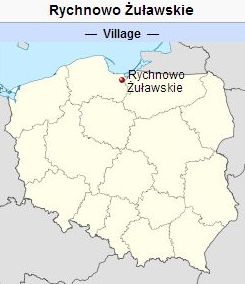
| − | + | [[File:Rychnowo%20Zulawskie.jpg|300px|thumb|right|''Rückenau (now Rychnowo Żuławskie, Poland) | |
Source: [http://en.wikipedia.org/wiki/Rychnowo_%C5%BBu%C5%82awskie Wikipedia Commons] Wikipedia Commons Rückenau (now Rychnowy, Poland) | Source: [http://en.wikipedia.org/wiki/Rychnowo_%C5%BBu%C5%82awskie Wikipedia Commons] Wikipedia Commons Rückenau (now Rychnowy, Poland) | ||
| Line 18: | Line 18: | ||
There was a second village in West Prussia known by the name Rückenau (now Rychnowy), located in the Warmian-Masurian Voivodeship<strong> </strong>approximately 30 km north-east of [[Elbing (Warmian-Masurian Voivodeship, Poland)|Elbing]] (coordinates: 54.25852° N, 19.61377° E [54° 15' 30.7'' N, 19° 36' 49.6'' E]; population in 1905, 227, in 1939, 157, in 2012, 90). It lies approximately 7 kilometres (4 miles) north-east of Milejewo (Trunz), 23 km (14 mi.) north-east of Elbląg ([[Elbing (Warmian-Masurian Voivodeship, Poland)|Elbing]]), and 79 km (49 mi.) north-west of the regional capital Olsztyn (Allenstein). | There was a second village in West Prussia known by the name Rückenau (now Rychnowy), located in the Warmian-Masurian Voivodeship<strong> </strong>approximately 30 km north-east of [[Elbing (Warmian-Masurian Voivodeship, Poland)|Elbing]] (coordinates: 54.25852° N, 19.61377° E [54° 15' 30.7'' N, 19° 36' 49.6'' E]; population in 1905, 227, in 1939, 157, in 2012, 90). It lies approximately 7 kilometres (4 miles) north-east of Milejewo (Trunz), 23 km (14 mi.) north-east of Elbląg ([[Elbing (Warmian-Masurian Voivodeship, Poland)|Elbing]]), and 79 km (49 mi.) north-west of the regional capital Olsztyn (Allenstein). | ||
| − | |||
| − | |||
= Bibliography = | = Bibliography = | ||
"Familienforschung in Westpreußen." Hans-Jürgen Wolf. Web. 29 September 2012. [http://www.westpreussen.de/cms/ct/ortsverzeichnis/details.php http://www.westpreussen.de] | "Familienforschung in Westpreußen." Hans-Jürgen Wolf. Web. 29 September 2012. [http://www.westpreussen.de/cms/ct/ortsverzeichnis/details.php http://www.westpreussen.de] | ||
| Line 30: | Line 28: | ||
"Rychnowy, Warmian-Masurian Voivodeship." Wikipedia. Web. 30 September 2012. [http://en.wikipedia.org/wiki/Rychnowy,_Warmian-Masurian_Voivodeship http://en.wikipedia.org/wiki/Rychnowy,_Warmian-Masurian_Voivodeship]. | "Rychnowy, Warmian-Masurian Voivodeship." Wikipedia. Web. 30 September 2012. [http://en.wikipedia.org/wiki/Rychnowy,_Warmian-Masurian_Voivodeship http://en.wikipedia.org/wiki/Rychnowy,_Warmian-Masurian_Voivodeship]. | ||
| − | |||
| − | |||
= Maps = | = Maps = | ||
Revision as of 19:31, 20 August 2013


Rückenau (now Rychnowo Żuławskie, Poland) Source: Wikipedia Commons Rückenau (now Rychnowy, Poland) Source: Wikipedia Commons Rückenau (also known as Richenow and Rychnowo; now known as Rychnowo Żuławskie; coordinates: 54.18692° N, 19.11348° E [54° 11' 12.9" N, 19° 6' 48.5" E]; population in 1905, 332, population in 2008, 200), is a village formerly inhabited by Mennonites in what was once known as the Gross-Werder area of West Prussia, now in Poland. It lies approximately 4 kilometres (2 miles) south of Nowy Dwór Gdański (Tiegenhof) and 38 km (24 mi.) south-east of the regional capital Gdańsk (Danzig). In 1936 there were 15 Mennonite families, of whom 11 were farmers, a total of 62 souls, who belonged to the Rosenort Mennonite Church in West Prussia. Their names were Braun, Friesen, Haese, Hein, Janzen, Klaassen, Neufeld, Penner, Regehr, Schröder, and Wiebe. There was a second village in West Prussia known by the name Rückenau (now Rychnowy), located in the Warmian-Masurian Voivodeship approximately 30 km north-east of Elbing (coordinates: 54.25852° N, 19.61377° E [54° 15' 30.7 N, 19° 36' 49.6 E]; population in 1905, 227, in 1939, 157, in 2012, 90). It lies approximately 7 kilometres (4 miles) north-east of Milejewo (Trunz), 23 km (14 mi.) north-east of Elbląg (Elbing), and 79 km (49 mi.) north-west of the regional capital Olsztyn (Allenstein).
Bibliography
"Familienforschung in Westpreußen." Hans-Jürgen Wolf. Web. 29 September 2012. http://www.westpreussen.de
Hege, Christian and Christian Neff. Mennonitisches Lexikon, 4 vols. Frankfurt & Weierhof: Hege; Karlsruhe: Schneider, 1913-1967: v. III, 560.
Mennonitisches Adressbuch. Karlsruhe, 1936: 167.
"Rychnowo Żuławskie." Wikipedia. Web. 30 September 2012. http://en.wikipedia.org/wiki/Rychnowo_Żuławskie.
"Rychnowy, Warmian-Masurian Voivodeship." Wikipedia. Web. 30 September 2012. http://en.wikipedia.org/wiki/Rychnowy,_Warmian-Masurian_Voivodeship.
Maps
Map:Rychnowo Żuławskie (Pomeranian Voivodeship, Poland) Map:Rychnowy (Warmian-Masurian Voivodeship, Poland)
| Author(s) | Ernst Crous |
|---|---|
| Richard D. Thiessen | |
| Date Published | September 2012 |
Cite This Article
MLA style
Crous, Ernst and Richard D. Thiessen. "Rückenau (Pomeranian Voivodeship, Poland)." Global Anabaptist Mennonite Encyclopedia Online. September 2012. Web. 19 Apr 2024. https://gameo.org/index.php?title=R%C3%BCckenau_(Pomeranian_Voivodeship,_Poland)&oldid=84759.
APA style
Crous, Ernst and Richard D. Thiessen. (September 2012). Rückenau (Pomeranian Voivodeship, Poland). Global Anabaptist Mennonite Encyclopedia Online. Retrieved 19 April 2024, from https://gameo.org/index.php?title=R%C3%BCckenau_(Pomeranian_Voivodeship,_Poland)&oldid=84759.
Adapted by permission of Herald Press, Harrisonburg, Virginia, from Mennonite Encyclopedia, Vol. 4, p. 375. All rights reserved.
©1996-2024 by the Global Anabaptist Mennonite Encyclopedia Online. All rights reserved.
